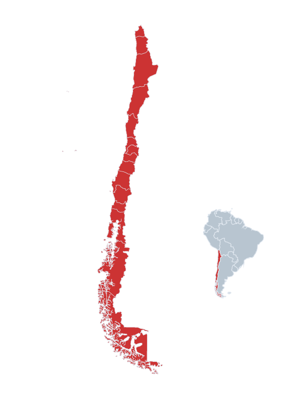
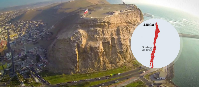
North / Arica
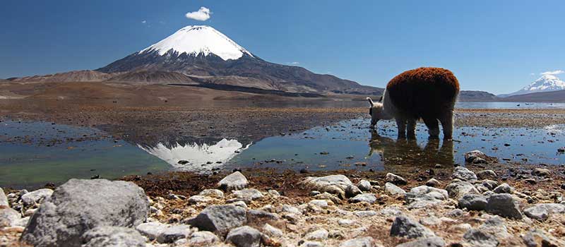
the “City of Eternal Spring” with French influences of Gustave Eiffel. Another hidden highlight is the Lauca National Park, the Chile's highest national park that drapes across northern highlands, 4,000m-6,000m up – a landscape of lonely altiplano lakes and jetting geysers, roamed by herds of wild vicuña, llama and alpaca. The interconnected Cotacotani lakes glitter in a dark lava field, while Lago Chungara washes the foot of a 6,330m volcano. The tiny village of Parinacota is the park's evocative HQ, huddled around a gorgeous church.
What can we do in Arica ?
-
Lauca National Park
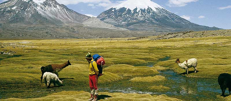
comprises the pre-cordillera and the Andean Highlands, in the east end of Arica and the Parinacota Region. This National Park represents not only the Highlands, but it has part of its surface in the pre-altiplanic desert steppe highlighting the volcanoes Parinacota (6342msnm), Pomerape, (6282msnm), Guallarite, (6060msnm), Acotango, and (6050msnm). In 1981, the Park was declared Natural Patrimony of Humanity and Biosphere Reserve by UNESCO.
-
Chungara Lake
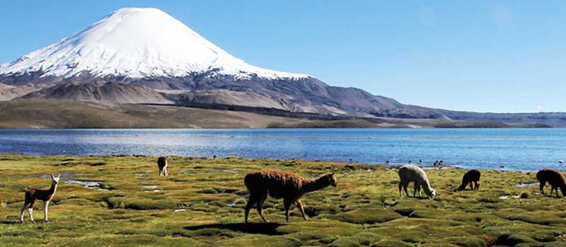
Natural Patrimony of Humanity and Biosphere Reserve, part of the Lauca National Park, is a beautiful emerald green lake with an active animal life on the banks of its waters and on the horizon, the Payachatas nevados, composed by the Parinacota and Pomerape volcanoes and the Sajama and the Guallitire nevados. The population is of Aymara origin, still preserving their cultural traditions, as the grazing of camelids, music, religious festivities and the cultivation of the quinoa, a grain from the Highlands.
-
Putre
Village of pre-Hispanic origin (altitude 3,500 m), today the capital of the province of Parinacota. Most of its buildings are from the 19th century. In front of the square stands the church built in l670, replacing its predecessor, destroyed in an earthquake and, that according to chroniclers, was cover with gold and silver. Currently declared National Monument.
-
Las Vicuñas National Reserve
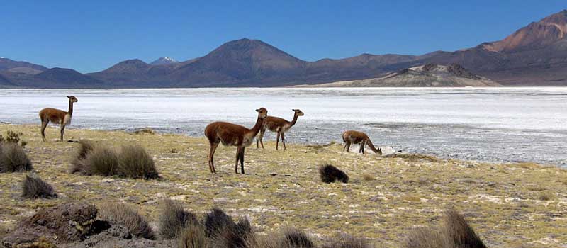
With a surface reaching 209.131 hectares, comprises the pre-cordillera and the Andean Highlands (4,300 and 5,800 meters) from the south-eastern tip of the Region of Arica and Parinacota, commune of Putre, south of the Lauca National Park and north of the Salar de Surire Natural Monument. This national reserve has part of its surface in the alto Andean steppe in the pre-cordillera. The higher elevations are the hills and volcanoes Puquintica (5.780 masl), Aritinca (5.999 masl), Belén (5.260 masl) and Anocariri (5,050 m). Various vestiges of pre-Columbian cultures outstand here, such as altars of Aymara origin. They still live in small settlements, examples of this culture dedicated to the herding of llamas and alpacas.
North / Iquique
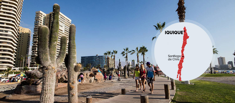
Bastion of the 19th-Century nitrate boom, with wonderful long white beaches. Located approximately 1,787 km from Santiago and 310 km from Arica, is a port-city, capital of the Province of Iquique and the Tarapacá Region, it also has the largest commercial rights in Southamerica for free-port activities or Zona Franca. Trade is very important because the region is the passage for Chilean products to Peru, Bolivia and Brazil, due to the existing interoceanic corridor, as well as being site to large-scale copper mining and the fishing industry. This area was the cradle to the Chinchorro Cultural Complex some 5,000 years ago, but important evidence has been found dating 4,000 years B.C.
What can we do in Iquique ?
-
Isluga Volcano National Park
(4,000 m), covers 174,744 hectares distributed among the communes of Colchane, Camina and Huara. Recorded as highest hills are the Quimsachata (5400 m), Tatajachura (5,252 m), Latarama (5.207 m) and the snow-capped Isluga volcano (5.550 m). The park includes the Arabilla River, the Quebrada de Aroma and the Parinacota, Arabilla lagoons, housing a great variety of birds. Another attraction is the Puchuldiza geothermal field consisting of geisers and hot springs with waters reaching up to 85°C. Fumaroles at dawn, which during the cold months transform into beautiful blocks of ice.
-
Salar de Huasco National Park
Salar de Huasco National Park has the category of Nature Sanctuary and it also part of the National State System for the Protection of Wild Areas. Standing out is a salt flat in the middle of two mountains that rise above 4,500 m. Being in an arid high plateau area it plays a fundamental role on biodiversity attracting birds around the Huasco lagoon, like the Andean, James flamingos and Andean seagulls and ducks. In this beautiful natural setting, it is also possible to see vicuñas and the Andean fox.
-
Salitreras of Humberstone and Santa Laura
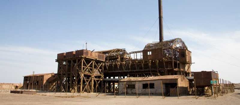
Salitreras of Humberstone and Santa Laura are two former saltpeters, declared National Monuments and Cultural Heritage, also included in the list of endangered world heritage. They are located in the commune of Pozo Almonte, 47 km from the city of Iquique. Currently, both mines are the main reflection of the splendor and contrasts of the region between the end of the 19th century and beginning of the 20th century. These mines are nowadays one of the main tourist landmarks of the region. It impresses to watch the vestiges of an era of so much wealth, even more so when major restoration works are in process in the hands of the Corporación Museo del Salitre and the Regional Government of Tarapaca..
-
Geoglyphs of Pintados
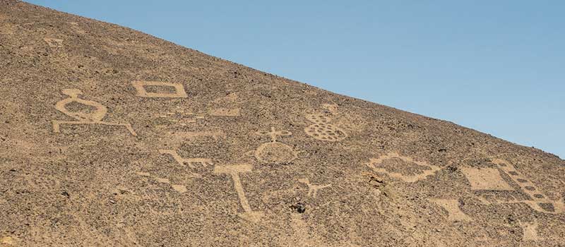
located in the Pampa del Tamarugal 95 km from Iquique. They correspond to Prehispanic cave manifestations dating back to the IX century B.C. found on the slopes of a hill showing large-size geometrical, zoomorphic and anthropomorphic figures. Much speculation regarding its usefulness; even that they may have served as a signal for extraterrestrial journeys. Cerros Pintados shows clear paths, part of the system of routes that crossed the desert to connect the coast with the pampa and the Andean altiplano. According to its stylistic pattern, it is possible to assume some cultural relation with the Tiwanaku culture interpreted as a pan-Andean religious site, between the 500 and 1.450 b.C.
-
Gigante de Atacama or Geoglyph of Cerro Unita
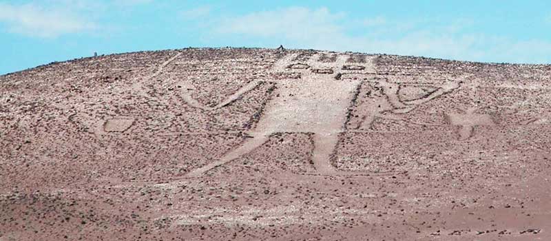
Gigante de Atacama of Geoglyph of cerro Unita is a figure drawn on the northwest flank of Cerro Unita, 15 km from the village of Huara in the Atacama Desert territory. It is assumed that the representation corresponds to a shaman or yatiri, (person who interacts with the physical and spiritual world), although it may also correspond to the Andean deity who made a voyage from Lake Titicaca to the Pacific Ocean.
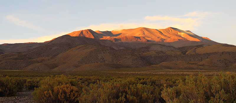
North / Atacama Desert
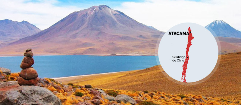
hidden treasures in the driest desert of the world. Minerals create lakes with otherworldly hues, while hot springs bubble amid rugged plains and salt flats. Snowcapped volcanoes, gigantic geysers, hot water springs amidst magical indigenous towns and villages. Altiplanic lagoons, a visual impact due to the beauty of its white edges of crystallized white salt against turquoise waters and pink flamingos on the background. Located at an average altitude of 2438 m Atacama, is consider the driest desert on earth, Archaeological Capital of Chile and main center of the Atacameño culture.
What can we do in Atacama Desert ?
-
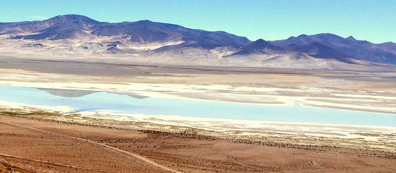
Atacama Salt Lake & Altiplanic Lagoons
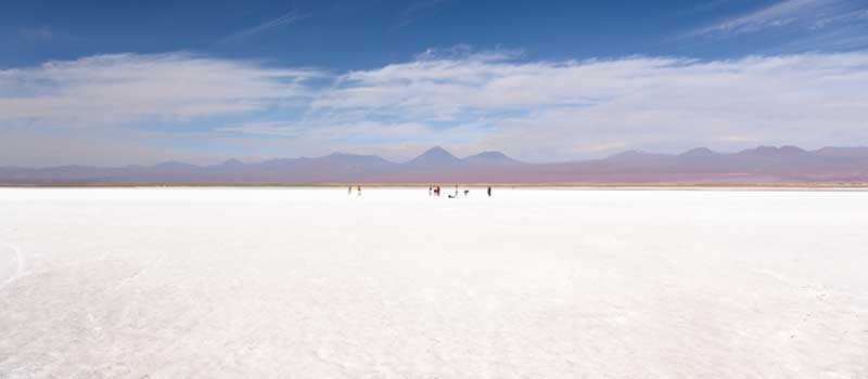
The departure to the Salar de Atacama with your tour guide is in the early morning. A salt lake of huge proportions (3000 sq km/1,158 sq mi!), its surface is covered by a thick layer of light-colored salt crystals, caused by the evaporation of the lake’s water. The world’s largest lithium deposits are found here, but the salt flat is also home to several flamingo species, including the Andean, Chilean and James flamingo, who feed on the microorganisms found in the saline lagoons. These beautiful birds and other species can be observed in their natural habitat at the Salar de Atacama’s Chaxa Lagoon, which is part of the Flamingo National Reserve.
The journey continues afterwards, to the tiny village of Socaire, set at 3218m/10,558ft, which is noteworthy for its strange architecture using rough stonework. The few inhabitants here still live by the age-old methods of planting terraced fields with corn, wheat and potatoes. A lunch-break is held here (lunch is not included), before the tour continues for about another 30km/19mi, climbing an additional 1000m/3,281ft in altitude to reach the highland lagoons of Miscanti and Miñiques, with their two – almost 6000m/19,686ft high – volcanoes of the same name in the background. The twin lagoons are a deep blue, each framed by a white salt crust, which creates a memorable contrast to the yellow highland grass all around. It is completely silent here. Even the duck species that breed here, the foxes, and the grazing vicuñas (a type of sheep), respect the majestic silence. During your return journey, you visit the green village square of the small oasis town of Toconao, with its large cacti and a white church with free-standing spire, and interesting constructions using cactus wood.
The drive back to San Pedro is in the late afternoon.
-
Moon Valley & Death Valley
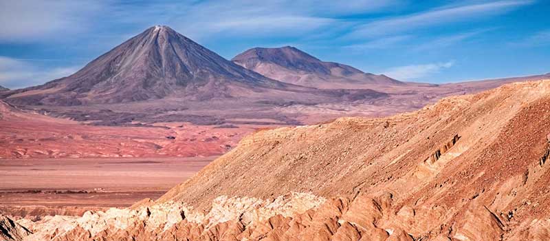
One of the best-known destinations between Calama and San Pedro is the Valle de la Luna. With the Licancabur volcano providing the backdrop, strange salt and rock formations in the middle of the valley’s barren sandy landscape really do look like a moonscape. After a tour past the bizarre natural rock and salt shapes, you will ascend a lookout point on a giant sand dune where you can enjoy a breathtaking view of the valley and the Licancabur volcano. Then, you pass by the bizarre rock formation “Tres Marías” and end the excursion at “Coyote´s rock” (“Piedra del Coyote”). From the top of this rock, you overlook the Kari-Canyon and wide parts of the desert, you can even catch a glimpse at the Salar de Atacama. The setting sun bathes the landscape in a light that changes with every minute, providing a mesmerizing play of colors.
We are also able to see the great Death Valley, characterized by its strange geological formations; incredible sculptures of rock and sand dunes in the complete dryness of the desert. The return drive to San Pedro is after sunset.
-
Geysers of Tatio
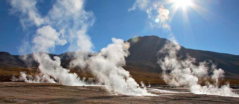
Those who wish to experience the El Tatio Geysers have to get up early, to ensure a timely arrival at the geyser field at sunrise. In this tour you are able to appreciate the imposing fumaroles that emerge through fissures in the earth’s crust caused by the contact of underground rivers of ice waters with hot rocks reaching 10 feet tall and 85°C. The fountains, located over 4300m/14,108ft, shoot up to 10m/33ft high. After the spectacular show there, you have the choice of recovering from the morning chill and warming up in natural pools created by hot springs.
So early in the morning, the temperatures at the Geysers can be far below 0°C we recommend to bring warm clothes.
Bring swimming gear, if you would like to warm up in the hot pools.
Note: The excursion to the Tatio Geysers can be combined with a visit to the little desert village Machuca (altitude: over 4000m/13,124ft), where the guests may try traditional lama meat and empanadas. Another very attractive option is the combination with the Puritama hot springs.
-
Arqueological Tour
This half-day tour follows in the footsteps of the ancient Atacameños and Incas, and your tour guide will show you two archaeological sites: Aldea de Tulor and Pukará de Quitor.
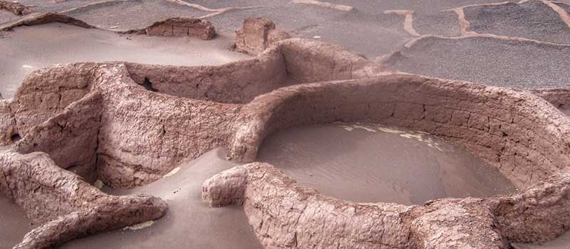
The Aldea de Tulor is a ruined village dating from around 800 BC, where once up to 200 inhabitants lived. Next to the ruins, two domestic buildings have been reconstructed according to authentic designs, and turned into a museum.
The fortress of Pukará de Quitor is just 3km/2mi north of San Pedro. It was erected by the Atacameños in the 12th century BC, and later extended by the Incas. The Spanish took the fort in 1540. There is a beautiful view towards San Pedro and the Andean mountain chain from the fortress, including of volcanoes in the background.
-
San Pedro de Atacama's Town
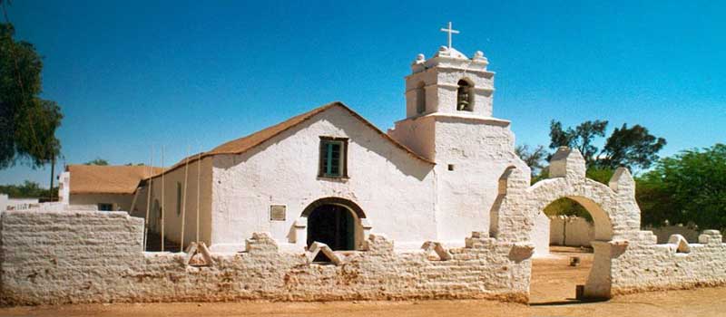
It is very suggested to visit this small oasis town of San Pedro de Atacama, in the middle of the Atacama Desert. Fortunately, this place with its sandy streets and low adobe houses does not seem to change, and appears almost untouched by the tourists, who come here to experience the incomparable Atacama Desert. We recommend you the visits to San Pedro Church, declared Historic Monument in 1951 and located next to the tree-lined San Pedro Main Square of beautiful Andean style constructed with indigenous adobe material. The walls, roof and the entrance doors are built with algarrobo wood (Prosopis alba), chañar (Geoffroea decorticans), and cactus wood, bound together with llama leather in a technique traditional to the altiplano. The construction of this church in the 17th century is what precisely gave gradual rise to the village. Other important highlight is the Gustav Le Paige Archeological Museum, Belgian Jesuit missionary who dedicated his life to the collection and study of archaeological remains. He took over the parish in 1955 until his death in 1980. Three pavilions show and illustrate the evolution of the people who inhabited the Atacama territory in its 11.000 years of development. Over 380.000 pieces of great archaeological beauty, ceramics in their various stages of development and ornamental objects.
-
Chuquicamata Copper Mine
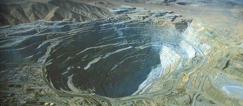
Visit Chuquicamata – the largest copper mine in the world, even visible from space! This giant hole in the desert landscape is the heart of Chile’s economy. Even the Inca already extracted copper here. In 1910 the first modern conveyor system was built and now 600.000t of copper are produced here annually. The main pit is over 4km/2.5mi long, 3km/2mi wide and 850m/2,789ft deep – until now.
Note: Ideally you visit Chuquicamata from Calama, or on your way back from San Pedro to Calama. Permission for visitors is not guaranteed and may depend on the work carried out at the mine on that precise day.
-
Uyuni Salt (Bolivia)
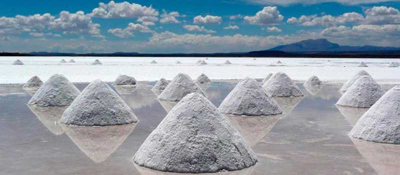
Is the greatest salt desert in the world with an area of 10,582 km2, located at 3.650 m above sea level in the southeast of Bolivia within the Altiplano of the Andes region. The salar (salt flat), is one of the largest reserves of lithium in the world, as well as potassium, borox and magnesium. The salar contains over 10 billion of salt, of which 25,000 tons extracts annually, and houses 140 million tons of lithium. Each November the Salar de Uyuni becomes the breeding site for three species of flamingoes, Chilean, of James and Andean.
North / La Serena
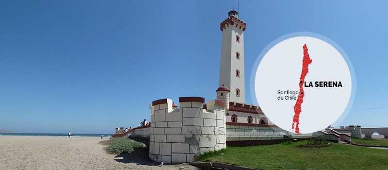
a beautiful city center, mile-long beaches, and an ideal starting-point for excursions to the famous Elqui Valley. Originally inhabited the pre-Hispanic people known as diaguitas, is capital of the Coquimbo Region, part of the Elqui Province, founded in 1544. La Serena is the second oldest city in Chile, with a beautiful colonial architecture characterized on their balconies, small squares and several century old churches. In 2013, La Serena positions as the first city in the country in terms of quality of life, considering aspects such as public safety, climate, environment, connectivity and the beauty of its buildings.
What can we do in La Serena ?
-
Humboldt Penguins National Reserve
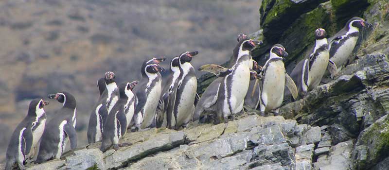
located 100 km north of La Serena, with a total area of 888.68 hectares, is composed by three islands: Chañaral, Choros and Damas, part of the Chilean National System for Protected Wild Areas, and managed by the National Forestry Corporation, (CONAF). In Punta de Choros, a small fishing port, it is possible to embark for Damas Island for the observation of the Humboldt penguins, (Spheniscus humboldt), endemic to the Humboldt current and inhabitants in Chile from Arica, (border with Peru), to the islets of Puñihuil in Chiloé, in the lake district. During navigation, view sea lions, pelicans, colonies of Bottle Nose dolphins, (Tursiops truncatus), and occasionally fin, blue and humback whales.
-
Flowering Desert
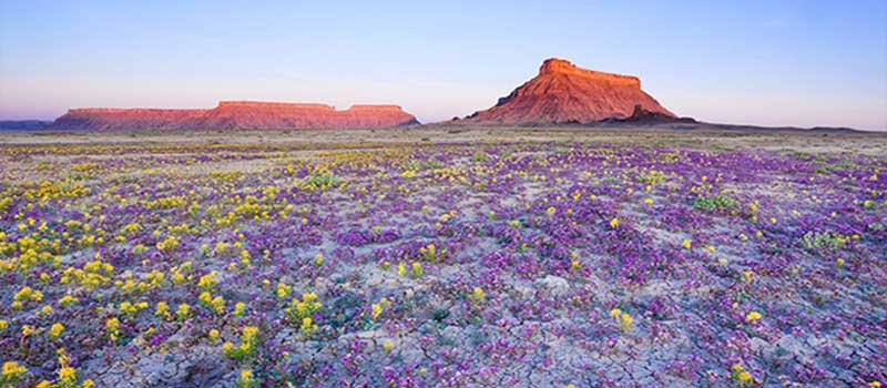
from la Serena, at approximately 40 km, appears a broad plain surrounded by high hills. From here, to the city of Copiapo, after a rainy winter happens the so-called “blooming desert”, a unique phenomenon that occurs in Atacama, the driest desert in the world. Flowering begins in late July and August, depending on rainfalls and temperatures, and can continue until November, which is determined according to each zone. During these months, more than 200 species appear. For extended sectors, the desert is cover by an amazing array of colors. During these last years, due to various factors, such as the illegal trade of these species and the development of international races in the desert, (Dakar), environmentalists have denounced the progressive destruction of this heritage. Faced with this, the Government of Chile has established a series of limits and prohibitions.
-
La Recova
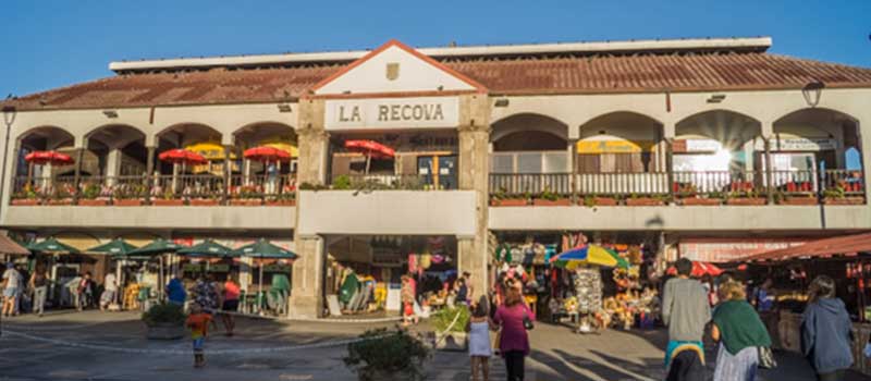
whose origins as a central market dates back to colonial times, houses today a complete collection of objects from pre-Hispanic cultures, especially in combarbalita, semiprecious lapislazuli jewelry, stone ceramics with diaguita motifs and alpaca wools from Peru and Bolivia. Recova takes its name from the arches with the colonial canons of the time of its construction. (*Combarbalita, semi-precious rock of volcanic origin which has been handcrafted from pre-Hispanic times. * Lapis lazuli, semiprecious stone consisting of mineral lazurite, silicatocalcico, which provides the blue color, wollastonite and calcia, which produces the grey and white marbling, and pyrite which produces golden reflections, used in the creation of jewelry in Chile).
-
Coquimbo
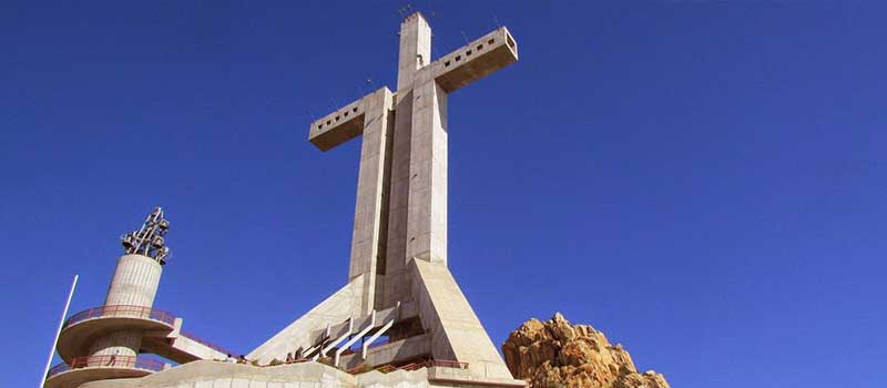
capital of the Elqui Province, located 12 km south of La Serena, is a port city also, site for the well-known Las Tacas and Puerto Velero summer resorts. In the center of the city is found one of the highest symbols of Southamerica, in what relates to the Christian culture - the Cross-of the Third Millennium - located atop the Vigia Hill. A spectacular construction erected in tribute to the 2,000 years of the birth of Jesus Christ. From the Mirador de los Navegantes (viewpoint), you obtain a spectacular full view of the Herradura and Guayacán bays. Facing the square is the Church of Guayacán, designed and manufactured by the french Eiffel works industry, brought from Belgium in 1888.
-
Fray Jorge National Park
located in the Limarí Province, Region of Coquimbo, created in 1941 to preserve an important ecosystem of Chile, declared Biosphere Reserve by UNESCO in 1977 and whose main attraction is a lush Valdivian forest next to the Atacama Desert, the driest desert in the world. Due to this natural phenomena, various species of Chilean flora is found in this forest, such as the “olivillo” (Aextoxicon punctatum), the “medallita” creeper (Sarmienta scandens) and the copihue (Lapageria rosea), considered the national flower of Chile, apparently introduced to the park during the 20th century, as well as cinnamons, olivillos and a wide variety of ferns. * This Park is located 150 km south of La Serena (1h45m), in the chain of hills of the Cordillera de la Costa, bordered on the West by the Pacific Ocean and to the South by the Limarí River.
-
The Observatories of the Region of Coquimbo
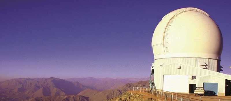
as clear skies for observation are excellent in this Region; several and famed astronomical observatories are equipped with powerful and sophisticated instruments. Best known in this area are El Tololo, La Silla and Las Campanas.